

Garmin
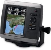
GPSMAP 521 Chartplotter GPS
- 7.6 x 10.2 cm, 12.7 cm diagonal Display, Accepts Secure Digital (SD) data cards - Note: (Just a chartplotter)
Model: 521
Mnf. #: 010-00760-00
SKU: 18949
Warranty: 1 year
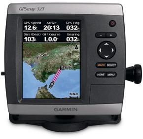
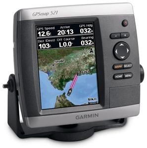
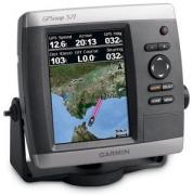
The GPSMAP 521 is a compact chartplotter that features an ultra-bright 5” QVGA color display along with an improved high-speed digital design for increased map drawing and panning speeds. It’s ready to go with a built-in, satellite-enhanced worldwide basemap and an easy-to-use interface designed to help you navigate the open waters with ease. The GPSMAP 521 also accepts BlueChart® g2 Vision cards for added features and functionality such as high-resolution satellite imagery, 3D views and Auto Guidance technology.
View Satellite-enhanced Worldwide Basemap
The GPSMAP 521 basemap contains worldwide satellite images in place of traditional maps. The GPSMAP 521 also comes standard with a high-sensitivity GPS receiver for superior satellite tracking and quicker acquisition times. In addition, the GPSMAP 521 can receive U.S. graphical weather data via optional GXM 51 satellite receiver/antenna. And with an SD card slot, it’s easy to add additional maps without connecting to a computer.Add Sonar
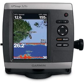
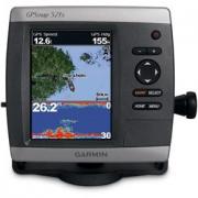
Where applicable, the sounder version, GPSMAP 521s, comes with a powerful dual-frequency transducer that clearly illustrates depth contours, fish targets and structures whether you’re fishing in freshwater or off the coast. The GPSMAP 521 and GPSMAP 521s are also NMEA 2000-certified for easy connectivity with sensors, instruments and future marine offerings.Add Extras with BlueChart g2 Vision
With the optional BlueChart g2 Vision SD card, you can add a whole new dimension of exceptional features to your chartplotter.- 3D Mariner’s and Fish Eye view provides you with a 3-dimensional perspective of map information, both above and below the waterline
- High-resolution satellite images and aerial photographs help you orient yourself in unfamiliar areas
- Auto Guidance technology searches through all relevant charts to create a route you can actually follow — one that avoids obstacles, shallow water, buoys and other obstructions
General |
||
| Product Line | GPSMAP | |
| Brand | ||
| Model | 521 | |
| Type | Chartplotter | |
| Built-in Speaker | - | |
Display |
||
| Display Size | 7.6 x 10.2 cm, 12.7 cm | |
| Type | QVGA | |
| Touch Screen | ||
| Resolution | 234 x 320 | |
Memory |
||
| Memory Card Slot | Yes | |
| Internal Memory | - | |
| Compatible Memory Cards | SD | |
Software & Maps |
||
| Included Maps | - | |
| Ability To Add Maps | ||
Interfaces |
||
| USB | - | |
| Bluetooth | - | |
| Wi-Fi | - | |
Features |
||
| Voice Prompts | - | |
| 3D Map Perspective | Yes with optional BlueChart g2 Vision card | |
| TMC (Traffic Message Channel) Support | ||
| Hunt/fish calendar | - | |
| Receiver | Yes | |
| Remote Control | - | |
Power |
||
| Battery | ||
| Battery Life | ||
Physical Dimensions |
||
| Width | 150 mm | |
| Height | 74 mm | |
| Depth | 163 mm | |
| Weight | 800 grams | |
Optional Accessories |
||
| Mounts | 010-10447-05 010-10921-00 010-10930-00 | |
| Cables | 010-10917-00 010-10918-00 010-11076-00 010-11076-01 010-11076-02 010-11076-03 010-11079-00 010-11089-00 | |
| Bags, Cases & Covers | 010-10912-00 | |
| Memory Cards | 010-10636-02 | |
| Antennas | 010-00872-00 | |
| Transducers | 010-10105-00 010-10106-00 010-10107-00 010-10182-00 010-10182-01 010-10192-01 010-10193-01 010-10194-00 010-10194-01 010-10200-00 010-10218-00 010-10224-00 010-10225-00 010-10249-00 010-10251-00 010-10253-00 010-10272-00 010-10279-01 010-10327-00 010-10365-00 010-10715-00 010-10716-00 | |
| Others | 010-00671-00 010-00701-00 010-00701-01 010-00702-00 010-00702-01 010-00703-00 010-00704-00 010-00705-00 010-00705-20 010-00737-00 010-00753-00 010-10817-01 010-10817-02 010-11050-00 010-11050-20 010-11051-00 010-11078-00 010-11080-00 010-11081-00 010-11096-00 010-11105-00 010-11105-01 K00-00368-00 | |
Package Content
- GPSMAP 521/521s*
- Tilt/swivel mount
- Protective front cover
- Power/data cable
- Documentation